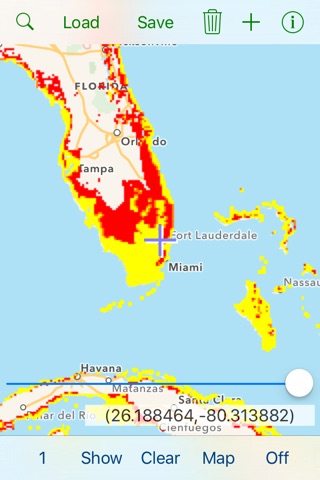

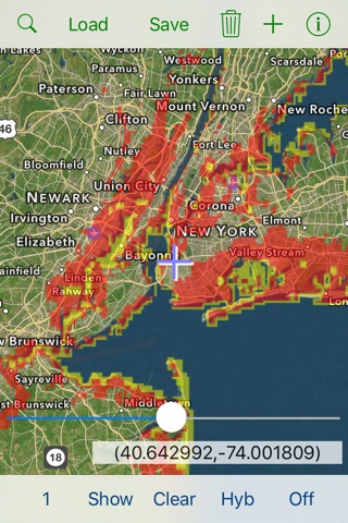
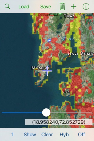

Download landcover, elevation, and population data that covers the entire planet. See possible future sea-level changes caused by global warming.
Create and save map overlays (KML ground overlay format). Export to your computer with iTunes File Sharing. You can also display standard KML/KMZ files containing point, line, and polygon features, as well as your own ground overlays (lat/lon box format only).
N.B. GeoData is based on Global AVHRR Landcover created by Univ. Maryland, Dept. Geography (30 arc-second per grid cell, 13 distinct landclasses), GLOBE Elevation provided by NOAA (meters above sea-level, 30 arc-second per grid cell), and Gridded Population produced by SEDAC/Columbia Univ. (persons per sq. km, 2.5 arc-minute per grid cell).
Details:
Landcover classes: Water, Evergreen Needleleaf Forest, Evergreen Broadleaf Forest, Deciduous Needleleaf Forest, Deciduous Broadleaf Forest, Mixed Forest, Woodland, Wooded Grassland, Closed Shrubland, Open Shrubland, Grassland, Cropland, Bare Ground, Urban and Built Up.
Elevation data is displayed as a false color image. To obtain the actual elevation value (in meters), convert the red-green-blue value to hue-saturation-brightness. The elevation is hue*8848/359.
Population data is displayed as a false color image. To obtain the actual population density (in persons per sq. km), convert the red-green-blue value to hue-saturation-brightness. The population density is exp(hue*log(29650)/359).
Sea-Level changes are encoded as follows: yellow (4.8 meter rise caused by West Antarctic ice sheet), orange (additional rise to 7.2 meters caused by Greenland ice sheet), and red (12 meter combined rise).